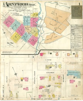
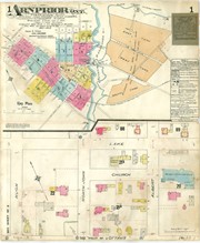
Fire Insurance Plan of Arnprior. Original 1902, revised to 1912. Sheet 1 of 12.
https://search.adarchives.org/en/permalink/archivaldescr190
- Date
- 1902-1912
- Collection/Fonds
- Arthur McLean fonds
- Description Level
- Item
- Physical Description
- Book ; 12 sheets
- Size: 63 x 53
- Reference No.
- M001
1 image
1 large document
- Date
- 1902-1912
- Format
- map
- Collection/Fonds
- Arthur McLean fonds
- Description Level
- Item
- Reference No.
- M001
- Publication
- Chas. E. Goad Co., Civil Engineers
- Underwriter's Survey Bureau Limited, Montreal & Toronto.
- Physical Description
- Book ; 12 sheets
- Size: 63 x 53
- Material Details
- key plan: 1 in. = 500 ft. ; section 1: 1 in. = 50 ft.
- Scope and Content
- Sheet 1 of 12. This Fire Insurance Plan shows the identification and location of buildings and streets in Arnprior in 1902 with revisions up to 1912, with a particular focus on building type, size and construction materials used as well as locations of hydrants and other fire protection facilities. The Key Plan on sheet 1 shows a plan of the whole of Arnprior, with street areas marked by sheet number & colour. The numbers on the Key Plan correspond to the sheet numbers in the book. It also includes a 'Key' or legend that is to be used to decipher the symbols on the rest of the plans in the book. The lower half of the page shows section 1, comprised of Hugh Street (now Bell), John Street North, Church Street, Lake Street and Albert Street, including St. John Chrysostom Roman Catholic Church.
- Access Restriction
- CLOSED due to deterioration. Use digital copy only, available in the Resources folder.
- Reproduction Restriction
- None
- Accession No.
- 1996-0067
- Subject Access
- Maps - Fire Plan
- Geographic Access
- Arnprior
Large Documents