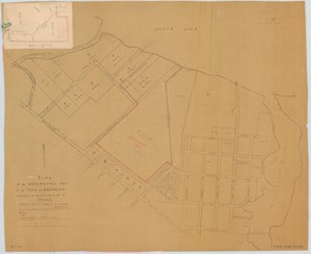
Plan of the Northwesterly part of the Town of Arnprior and pt. of the Township of McNab
https://search.adarchives.org/en/permalink/archivaldescr350
- Date
- 1936
- Collection/Fonds
- McLachlin Bros. fonds
- Description Level
- Item
- Physical Description
- paper print
- Size: 68 x 55
- Reference No.
- M009
1 image
1 large document
- Date
- 1936
- Format
- map
- Collection/Fonds
- McLachlin Bros. fonds
- Description Level
- Item
- Reference No.
- M009
- Physical Description
- paper print
- Size: 68 x 55
- Material Details
- Scale: 1 in. = 4 chains
- Scope and Content
- Shows streets and some lots from Madawaska River to Dochart Creek between Chat Lake and Elgin/Seymour St. Copy of map #8, with red pencilled informaton including D.A. Gillies holdings, 1936 (Grove Boundaries)
- Notes
- some attachments showing sketches with survey data and lot acreages around Dochart - dated 1936
- Accession No.
- 2004-0168
- Subject Access
- Maps - Lot Plan
- Geographic Access
- Arnprior
Large Documents